If you read the three
letters as a two-syllable word, "SI-A", you will
find in it the well-know intelligence service of the United
States of America (CIA as it is pronounced in Greek).
However, if you read it as a single-syllable word you will
find the likeable name of the Sia village and you will be
pronouncing the name of the only one-syllable village in Cyprus.
You will be surprised to know that this single-syllable name
hides in it a long and painful historic period of our island.
This was the period of the Arab raids that lasted over a
thousand years (500 -- 1500 AD). The Arab raids were not organised
campaigns of conquest. They were predatory armies organised
by warlords so as to loot and steal -ravishing the people's
crops, their animals, and the people themselves to be sold
as slaves.
These raids occurred mainly in the island's southern coastline.
After ransacking the coastal areas, the mighty armies took
the road towards the inland and up to the capital, which always
possessed the wealthiest pillage. The route to Nicosia was
the road constructed by the Romans (the "sierostrata"
-the "iron road" -as the locals called it) and -more
or less -it was the same as today's Nicosia - Limassol highway.
The community was located next to that passage but the troops
could not discover it, since it was set in a basin surrounded
by mountains that -indeed -were ridden with tall trees, mainly
pines and other thick vegetation. So, it was protected by
the eyes of the raiders because of being inside a "Siasma"
(a shadowy place). Thus, Sia was born as the name of a community.
This is the logical conclusion drawn from the nature of things.
However, there are no historical facts regarding the name.
The basin in which our ancestors created this community, apart
from the defensive advantage of the "shadowy area",
also had what was necessary so as to sustain itself; two rivers,
which had water throughout the year. The area between the
rivers (about one kilometre) is mainly rocky and at a significant
altitude above the riverbed, in a way that the village does
not face any danger from floods. Next to the rivers, fields
shaped by alluvial soil -and thus fertile -were able to yield
any kind of produce.
Woodcutting, which was the only source of heating and energy,
was still easy for them and quite auspicious, since they supplied
the lowland communities. Large tracts of land were there for
pasturage and the keeping of herds. And so, the community
survived through the millennia of Cyprus's known history.
One solid element indicating the assiduity of the community's
founders, regarding their defence from the raids, is the cave
that exists at the centre of the community, which -as the
elders testify - has a length of about 100 metres and a width
of 4-5 metres. Today it is closed and unknown to the younger
generations, because the Council and the Antiquities Department
showed no interest in its exposure. The cave was large enough
to conceal the community's populace and their animals. What
we don't know -and which archaeology's axe can ascertain -is
whether it was a natural one or if it was made by human hands
of that era.
In various areas of the community there are ancient ruins
and tombs. Their existence proves that there was a settlement
there during the antiquity. Preliminary researches (systematic
ones have not been conducted) revealed remains of a settlement,
more likely of the Roman times, located about 2 kilometres
north of the village. There are also indications that there
was in the region a settlement belonging to the prehistoric
times.
Sia, during its age-long and turbulent history, has gone through
several fluctuations of its population. Analytically, the
inhabitants of the community in 1881 were 177, decreasing
to 115 in 1891, increasing to 230 in 1901, to 241 in 1911,
to 251 in 1921, to 266 in 1931, to 338 in 1946, to 434 in
190, and to 396 in 1976. In 1982 the inhabitants decreased
down to 369. In the last population census that was done in
2001 the inhabitants were 530.
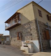
Today Sia is in a state of rapid development (a fact made
obvious also by the significant increase of its population).
Administratively it belongs to the capital, from which it
is only 28 kilometres away and with which it is connected
through the modern Nicosia -- Limassol highway. It has a distance
of only 26 kilometres from the city of Larnaca and its sea
and connects to it via the Mosfyloti - Psevdas - Agia Anna
- Kalo Chorio road and the Pera Chorio -- Larnaca motorway.
Its geographical position, along with the fact that it is
the first pine-clad, semi-mountainous region after Nicosia,
makes it a much sought after region with regards to acquiring
a permanent residence.
|